Smarter Flood Maps Could Change How We Prepare For Disasters
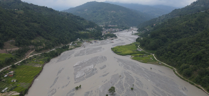
In the eastern state of Bihar lies the Kosi Megafan, sometimes called the “Sorrow of Bihar.” This giant, fan-shaped floodplain has been built up over thousands of years by the Kosi River, which spills out of the Himalayas. Unlike calmer rivers, the Kosi is restless—it frequently jumps course, breaking embankments and carving new channels. Entire villages find themselves on the wrong side of a river overnight.
If you live in a farming village there, the monsoon months bring both hope and dread: rain nourishes crops, but sudden floods can undo a season’s work in a single night. Urban residents in Patna or Kathmandu know the feeling too, as roads vanish under water and drainage systems buckle.
Why Flood Maps Fall Short
Governments have long tried to map “flood zones,” but traditional methods are blunt tools. They rely heavily on past records, topographic surveys, or simple rainfall thresholds. But climate change is making rains heavier and more erratic, while rapid urbanization covers land with concrete that speeds up runoff. Yesterday’s flood maps often fail to predict tomorrow’s disasters.
That’s where machine learning comes in. Instead of assuming floods follow the same old patterns, algorithms can learn from dozens of environmental and human factors simultaneously—from the slope of the land to the health of vegetation, from road placement to rainfall intensity.
Inside the Study: Teaching Machines to Read the Land
A research team led by Aman Arora and colleagues tested five different machine learning models on the Kosi Megafan:
- Artificial Neural Network – Multi-Layer Perceptron (ANN-MLP)
- Maximum Entropy (MaxEnt)
- Biogeography-Based Optimization (BBO)
- J48 Decision Tree
- Random Subspace Method
They trained these models using data from satellites such as Sentinel-2A and Landsat 5, radar sensors that penetrate cloud cover, and detailed soil and rainfall maps. In total, 19 “conditioning factors” were fed into the models—things like altitude, vegetation index (NDVI), distance to rivers and roads, and rainfall levels.
Think of it like teaching five students to predict which parts of a city will flood. Each student uses the same evidence, but their reasoning styles differ. Some spot clear rules (“near rivers = risky”), others find hidden patterns in the data.
The Winner: A Digital Brain Outperforms the Rest
Among the five, the ANN-MLP model outperformed the competition. It reached an astonishing 98.2% accuracy on validation data, with nearly perfect sensitivity and specificity. In plain terms: this model almost never missed a flood-prone area, and it rarely flagged a safe zone as dangerous.
The MaxEnt model also performed strongly, especially valuable when data are patchy—a common reality in many low-resource countries. The other models still provided valuable insights but fell short in precision.
What the Models Revealed
The analysis revealed that not all factors are equally important. The five most important predictors of flood risk in the Kosi Megafan were:
- Vegetation health (NDVI) – Lush green cover slows down water and soaks it up.
- Altitude – Low-lying areas are natural traps for floodwaters.
- Distance to road – Roads can block drainage, creating mini-dams.
- Rainfall – More intense monsoons mean higher risk.
- Distance to river – The closer you are, the greater the dangers
This mix is telling. Floods aren’t just about how much it rains. Human choices—such as where we build roads and how much forest we clear—directly affect how water moves across the land.
Why It Matters Beyond India
While this study focused on Bihar, its lessons stretch across the globe.
- In Nigeria’s Niger Delta, road construction through wetlands has worsened seasonal flooding.
- In Brazil’s Amazon basin, rapid deforestation changes runoff patterns, putting riverine towns at risk.
- In Bangladesh, one of the world’s most flood-prone countries, detailed AI-driven maps could guide embankment planning and early warnings.
Machine learning offers a way to adapt flood planning to local realities—whether that’s a Himalayan megafan, a coastal delta, or an urban sprawl.
A Twist: Accuracy vs. Usability
There’s one caveat. While the ANN-MLP model was the most accurate, it also produced slightly more “false alarms” in low-to-moderate risk areass. For governments and communities, that can mean tough choices: Do you evacuate a neighborhood every time there’s a warning, even if floods don’t always come?
Here lies a key tension in disaster science: perfect safety often comes at the cost of higher disruptions. That’s why pairing these models with local knowledge—farmers’ wisdom about river behavior, or engineers’ insights on drainage—is essential.
Let’s Explore Together
This study shows the power of blending earth observation, human factors, and AI to tackle one of humanity’s oldest enemies: floods. But it also leaves open questions worth discussing:
- Could such models be scaled down to the village level, where decisions are most urgent?
- How might low-income countries access the computing and data resources needed?
- What other community-level knowledge should be built into these systems?
Science gives us sharper tools, but the real test is how we use them. Could your city or village benefit from this kind of flood-smart mapping? What would you add to the model if you were on the research team?